WinField United Professional Products will launch the GeoTech insight platform – a comprehensive facility management system – at the 2017 Golf Industry Show in Orlando.
The GeoTech insight platform leverages the full power of imagery from satellites, airplanes and drones to help golf course superintendents:
--Identify and document plant health concerns.
--Design corrective solutions.
--Make accurate input applications.
--Keep track of treatments and results.
While satellite imagery programs have been around for awhile, they lack the robust software and smart data management that powers the GeoTech™ insight platform. This amplified technology is designed to provide insights that enable superintendents and other plant managers to better utilize labor resources, manage input costs and help increase sustainability, making it the first comprehensive facility management system of its kind in the golf course industry, says John Smith, Marketing Manager, WinField United PPG.
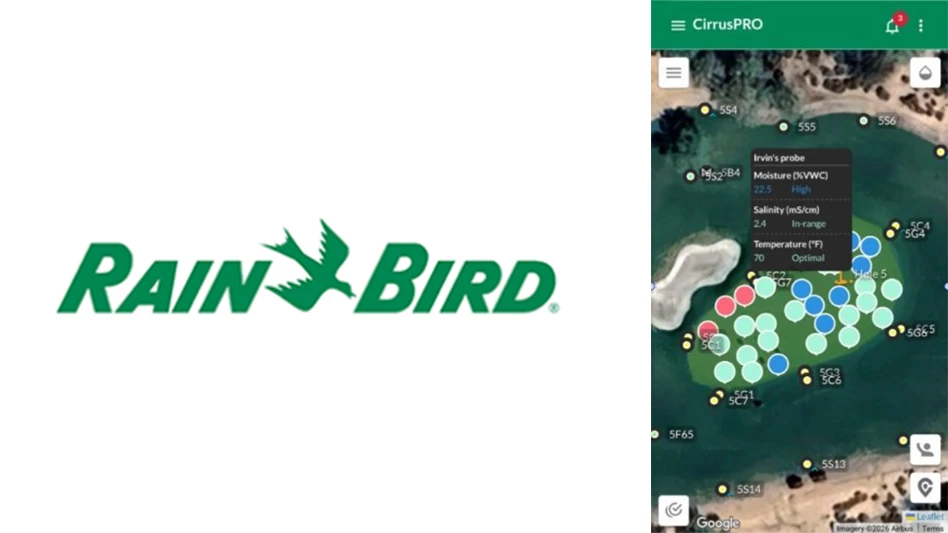
“GeoTech takes existing technology steps further by using proprietary algorithms to analyze imagery and provide color-coded maps that show variances in plant health,” Winfield marketing manager John Smith said. “Users can also upload their own data to create additional mapping layers, such as irrigation levels and soil and tissue samples.”
Once generated, these detailed maps can be used to pinpoint plant health problem areas that require scouting, document the findings and prescribe variable rate treatments that individually address each area of concern.
“GeoTech streamlines the scouting process by providing professionals with an easy-to-use dashboard to identify, record and track problems,” said Aaron Johnsen, Winfield director of regional sales and proprietary products. “Then decision makers can use the data they’ve gathered to create management zones based on plant health and design custom treatments for each spot. And they can fine-tune their use of inputs by utilizing GPS sprayers to automatically deliver precise, pre-determined amounts of product to each target area.”
The GeoTech insight platform creates these maps through the use of current ultra high-resolution imagery taken by airplanes or drones, current satellite imagery and 20 years of historical satellite imagery. Images are available with an annual service subscription, which provides new data every 10 to 14 days on average. Comparing historical and current imagery can help validate management practices and monitor changes over time.
The GeoTech insight platform leverages the full power of imagery from satellites, airplanes and drones to help golf course superintendents:
--Identify and document plant health concerns.
--Design corrective solutions.
--Make accurate input applications.
--Keep track of treatments and results.
While satellite imagery programs have been around for awhile, they lack the robust software and smart data management that powers the GeoTech™ insight platform. This amplified technology is designed to provide insights that enable superintendents and other plant managers to better utilize labor resources, manage input costs and help increase sustainability, making it the first comprehensive facility management system of its kind in the golf course industry, says John Smith, Marketing Manager, WinField United PPG.
“GeoTech takes existing technology steps further by using proprietary algorithms to analyze imagery and provide color-coded maps that show variances in plant health,” Winfield marketing manager John Smith said. “Users can also upload their own data to create additional mapping layers, such as irrigation levels and soil and tissue samples.”
Once generated, these detailed maps can be used to pinpoint plant health problem areas that require scouting, document the findings and prescribe variable rate treatments that individually address each area of concern.
“GeoTech streamlines the scouting process by providing professionals with an easy-to-use dashboard to identify, record and track problems,” said Aaron Johnsen, Winfield director of regional sales and proprietary products. “Then decision makers can use the data they’ve gathered to create management zones based on plant health and design custom treatments for each spot. And they can fine-tune their use of inputs by utilizing GPS sprayers to automatically deliver precise, pre-determined amounts of product to each target area.”
The GeoTech insight platform creates these maps through the use of current ultra high-resolution imagery taken by airplanes or drones, current satellite imagery and 20 years of historical satellite imagery. Images are available with an annual service subscription, which provides new data every 10 to 14 days on average. Comparing historical and current imagery can help validate management practices and monitor changes over time.
Latest from Golf Course Industry
- Tartan Talks 116: Doug Smith
- Audubon International adds 127 golf courses to Monarchs in the Rough
- USGA’s GAP preps for fourth year
- Protect your vehicles from rodent damage
- VIDEO: Fun with fairways
- From the publisher’s pen: Humble giving
- Syngenta adds two to western U.S. team
- The Aquatrols Company introduces soil surfactant for Canada