 The contiguous United States had its 11th warmest October on record, according to the latest NOAA State of the Climate report issued today. The average temperature for October was 56.9 F, which is 2.1 F above the 1901–2000 average. The average precipitation was 1.85 inches, which was 0.26 inch below the 1901–2000 average. The report, which draws from a network of long-term weather stations across the country, showed the combined average temperatures for the past three months (August–October) were the fifth warmest on record.
This monthly analysis, based on records dating back to 1895, is prepared by scientists at NOAA’s National Climatic Data Center <http://www.ncdc.noaa.gov> in Asheville, N.C., and is part of the suite of climate services NOAA provides.
U.S. Temperature Highlights — October
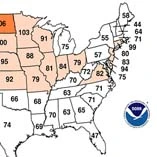
*Last month was the 11th warmest October on record in the United States. Warmer-than-normal conditions prevailed throughout the western U.S. and the Midwest. Only two of the U.S. climate regions <http://www.ncdc.noaa.gov/temp-and-precip/us-climate-regions.php> , both along the Eastern Seaboard, experienced average temperatures.
*No state had below-normal average temperatures. More than half of the U.S. was above-average. Wyoming had its fourth warmest October, and Montana had its seventh warmest.
U.S. Temperature Highlights —Year-to-Date
Record warmth has persisted throughout the year in the Northeast, where the average year-to-date temperature was 3.0 F above the 20th century average. So far, five northeastern states (New Hampshire, Vermont, Connecticut, New Jersey and Rhode Island) are having their warmest year on record. The western Great Lakes area also has been abnormally warm this year, about 2.5 F above the long-term average.
Texas and Florida were the only two states whose temperature was below average for the year-to-date period. Each had unusually cold months early in the year.
 U.S. Precipitation Highlights — October
Much of the western and northwestern United States experienced wetter than average conditions in October, while the Plains, Ohio Valley and the South were drier than average. The Northeast had its ninth wettest October, while the South climate region had its 10th driest.
Average precipitation across Florida was more than 3.4 inches below the long-term average, the driest October since statewide records began in 1895. Missouri experienced its fourth driest October and Texas its eighth driest.
A number of low-pressure storm systems in the West contributed to Nevada’s wettest October on record — 1.54 inches above normal — and brought California its seventh wettest. Elsewhere, Vermont had its second, New York had its fourth and New Hampshire had its fifth wettest October.
U.S. Precipitation Highlights —Year-to-Date
The Northern Plains and Upper Midwest have had much-above-average precipitation in 2010. So far, Iowa and North Dakota are having their second wettest year on record, Minnesota and Wisconsin their third, and South Dakota its eighth wettest.
Below average precipitation has persisted throughout much of the year in the South, where Louisiana is having its fifth driest year so far.
Other October Highlights
A powerful low-pressure system developed in the Upper Midwest on Oct. 25 and rapidly intensified the following day. The storm broke state records for lowest atmospheric pressure observed in Minnesota and Wisconsin. According to preliminary data from NOAA’s Storm Prediction Center, 72 tornadoes and 514 severe wind events were reported Oct. 24-27 from this system.
- According to NOAA’s Storm Prediction Center, there were 121 preliminary tornado reports nationwide during October. The final count will likely rank among the five busiest Octobers on record. Eight confirmed tornadoes in Arizona on Oct. 6 set a single-day record for the state.
- NCDC's Climate Extremes Index (CEI) <http://www.ncdc.noaa.gov/climate-monitoring/dyk.php?dyk=cei> , which measures the prevalence of several types of climate extremes, was about nine points higher than its historical average for the year so far. Factors contributing to this elevated 2010 value were large footprints of warm overnight temperatures, many locations experiencing a high number of rainy days and a large number of places with very high one-day precipitation totals.
Five hurricanes formed in the Atlantic basin in October, bringing the seasonal tropical cyclone count to 12 hurricanes and seven tropical storms. To date, the 2010 Atlantic hurricane season has had the third-most named storms, tying with 1995 and 1887. Only 2005 and 1933 have experienced more named tropical storms. So far, this year is tied with 1969 and 1887 for the second most Atlantic hurricanes, behind 2005.